


Les Orres - Pic de Boussole et Crête 09/08/2020

fredetpascale
User GUIDE
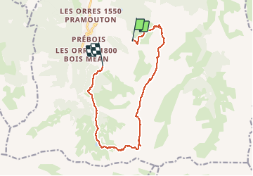

Length
13.8 km

Max alt
2851 m

Uphill gradient
872 m
Km-Effort
27 km

Min alt
1904 m

Downhill gradient
1209 m
Boucle
No
Creation date :
2020-08-09 07:28:00.616
Updated on :
2020-08-11 15:40:05.892
6h00
Difficulty : Difficult

FREE GPS app for hiking
 SityTrail
IGN / Geographical institutes
SityTrail Plus
The world is yours!
About
Trail Walking of 13.8 km to be discovered at Provence-Alpes-Côte d'Azur, Hautes-Alpes, Les Orres. This trail is proposed by fredetpascale.
Positioning
Country:
France
Region :
Provence-Alpes-Côte d'Azur
Department/Province :
Hautes-Alpes
Municipality :
Les Orres
Location:
Unknown
Start:(Dec)
Start:(UTM)
307254 ; 4929063 (32T) N.
Comments